HIER KLICKEN FÜR DIE DEUTSCHE VERSION
City Map - 4 different routes + PDF maps to download - Info below
With our book Street Art Guide Berlin on the way - walking or cycling through the city, with information about the artworks on the routes:
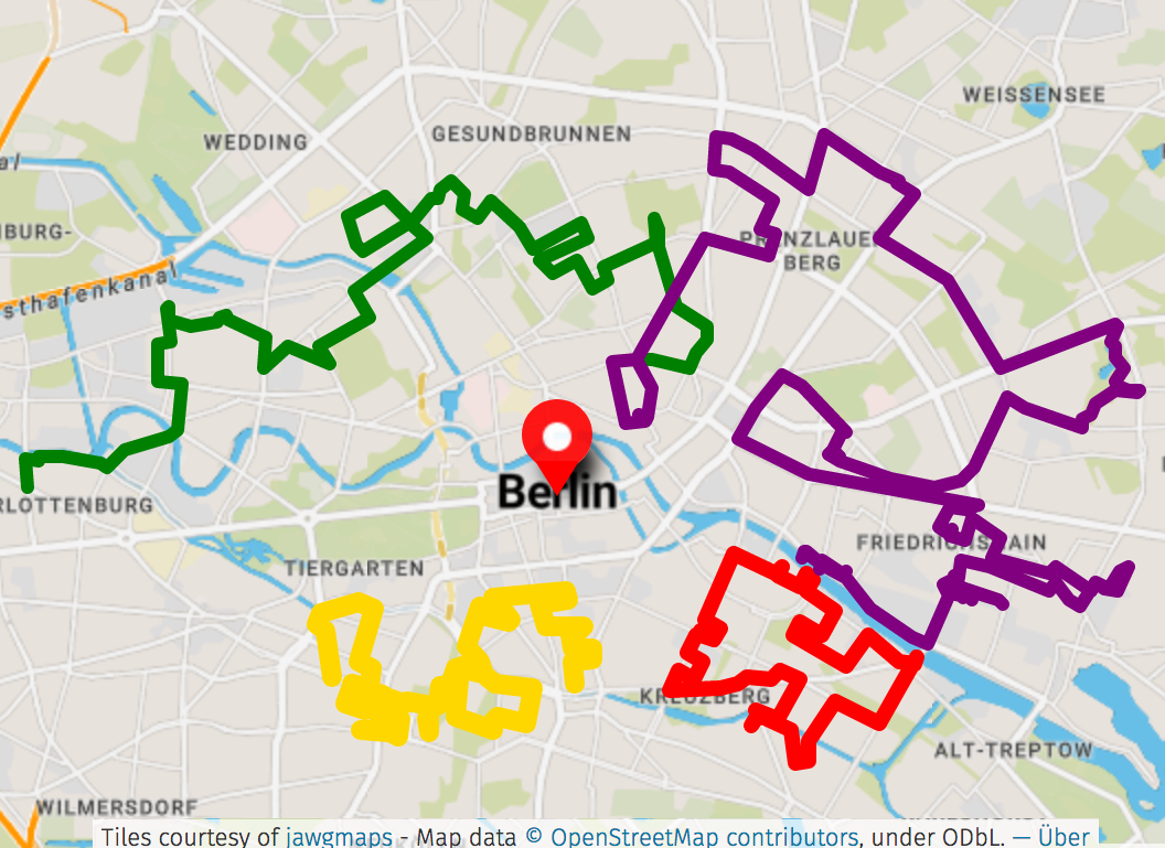
StreetArt Hiking Trail 1 ⬤
OBERBAUMBRÜCKE / SCHLESISCHES TOR - Kreuzberg, Neukölln, Mitte, Kreuzberg - OBERBAUMBRÜCKE / SCHLESISCHES TOR
Starting point / end point: Oberbaumbrücke / Schlesisches Tor - U1, U3
Length: 13km
Duration on foot: approx. 3:40h
Route: This hiking trail leads from the underground station Schlesisches Tor and Oberbaumbrücke through Kreuzberg, into various streets of the Wrangelkiez, through Falckensteinstraße, around Görlitzer Park, across Ohlauer Straße to Paul-Lincke-Ufer, across the Landwehrkanal, Maybachufer, into the Reuterkiez / Kreuzkölln. From there, before passing the ankerklause at Kottbusser Brücke, into Graefestraße to the haus, a culinary-artistic project by the curators of the berlin mural fest, the artist collective die dixons. We cross Reichenberger and Skalitzer Straße to Heinrichplatz, from where we continue via Kottbusser Tor towards Moritz Platz, along Heinrich-Heine-Straße. Passing the sage club / kitkat, republik berlin and tresor, we walk into Köpenicker Straße, past køpi with various murals and along Muskauer Straße, back to the starting point. Along the way you will come across street art works by blu, elle, paradox, smug, roa, one truth, findac, alaniz, tank, huariu, lake, herakut, case maclaim, various & gould, francisco bosoletti, young jarus, emily eldridge, onur, wes21, look & vidam.
Significant places:- Oberbaumbrücke
- Wrangelkiez
- Landwehrkanal
- Reuterkiez
- The Haus
- Heinrichplatz
- Kotti
- Heinrich-Heine-Straße
The routes are not signposted - either take our Street Art Guide book with you or follow the PDF maps - in print or on your mobile phone.
StreetArt Hiking Trail 2 ⬤
MEHRINGPLATZ / HALLESCHES TOR - Kreuzberg, Mitte, Schöneberg - NOLLENDORFPLATZ
Start: Mehringplatz / Hallesches Tor - U1, U3, U6
End point: Nollendorfplatz - U1, U2, U3, U4
Length: 15km
Duration on foot: approx. 4:10h
Route: This walking trail leads from Hallesches Tor underground station / Mehringplatz via Friedrichstraße and Wilhelmstraße past Checkpoint Charlie, westwards past the gropius bau, not far from Potsdamer Platz along Stresemannstraße southwards, via Bernburger Straße and Köthener Straße across the Landwehrkanal, along Tempelhofer Ufer until you cross the Park am Gleisdreieck. Here, open spaces such as the Stadtwildnis (city wilderness) and various spacious meadows and playgrounds for young and old meet modern architecture, urban big-city feeling with various underground lines crossing above ground and open-air bars with street food in summer. Here you will also find a graffiti and street art hall of fame, which is constantly being repainted by local and international artists. Continue westwards to the Schöneberg district, where you will also find the urban nation museum for contemporary art. Not only this street art hub is generously decorated by street artists inside and outside, but also the various side streets around the art museum on Bülowstraße. You will also pass a colourful construction fence of the bauhaus-archiv on Lützowufer. The route ends at Nollendorfplatz.
Along the way, you will come across murals by jadore tong, shepard fairey, aryz, james bullough, telmo miel, hrvb, innerfields, gert neuhaus, blek le rat, mateus bailon, nils westergard, findac, hyuro, bustart, cranio, kera1 und boa mistura.
Significant places:
- Mehringplatz
- Checkpoint Charlie
- Martin-Gropius-Bau
- Park am Gleisdreieck
- Urban Nation Museum for Contemporary Art
- Bauhaus-Archiv | Museum für Gestaltung
The routes are not signposted - either take our Street Art Guide book with you or follow the PDF maps - in print or on your mobile phone.
StreetArt Hiking Trail 3 ⬤
RICHARD-WAGNER-PLATZ - Charlottenburg, Moabit, Wedding, Gesundbrunnen, Mitte, Prenzlauer Berg, Mitte - ROSENTHALER PLATZ
Starting point: Richard-Wagner-Platz - U7
End point: Rosenthaler Platz - U8
Length: 19km
Duration on foot: approx. 5:20h - or walk it in several parts ;)
Route: From Richard-Wagner-Platz underground station in Charlottenburg, head northeast along the banks of the Spree river, cross the Dove Bridge, into Helmholtzstraße and across Gotzkowsky Bridge into Moabit. Pass various international restaurants in Gotzkowkskystraße and Huttenstraße, to the S-Bahn ring station Beusselstraße, from where a mural by hera can be seen across the tracks. Continue via Siemensstraße to Moabiter Stadtgarten, where the zk/u (zentrum für kunst und urbanistik) and a wall by 21ergallery are also located (pedestrian path between Erna-Samuel-Str. and Siemensstr.).
Passing the Poststadion (skate park), you will find another 21ergallery wall colourfully decorated with spraycans. We continue northeast through Wedding between Leopoldplatz and Reinickendorfer Strasse, on to Gesundbrunnen, past the panke cultural centre, past Volkspark Humboldthain, through the neighbourhood around Voltastrasse and Bernauer Strasse, which is also close to the Berlin Wall memorial. We make a detour to Mauerpark, not for the flea market, but for the Graffiti and Street Art Hall of Fame there. Now we head south again via Schwedter Straße, Schönhauser Allee not far from Rosa-Luxemburg-Platz with the Volksbühne Berlin and then via Torstraße to Rosenthaler Platz, where Street Art Hiking Trail 3 ends and Hiking Trail 4 begins.
Here you will come across works by, e.g. gert neuhaus, herakut, wes21, onur, ben wagin, victor ash, innerfields, kera1, low bros, tristan eaton, snik und nuno viegas.
Significant places:
- Spreeufer
- ZK/U (Zentrum für Kunst und Urbanistik)
- PANKE
- Volkspark Humboldthain
- Bernauer Straße
- Mauerpark
- Torstraße
- Rosenthaler Platz
The routes are not signposted - either take our Street Art Guide book with you or follow the PDF maps - in print or on your mobile phone.
StreetArt Hiking Trail 4 ⬤
ROSENTHALER PLATZ - Mitte, Prenzlauer Berg, Friedrichshain - OSTBAHNHOF
Starting point: Rosenthaler Platz - U8
End point: Ostbahnhof - S
Length: 31,3km
Duration on foot: approx. 8:40h - or walk it in several parts ;)
Route: Route 4 starts where Route 3 ends - at Rosenthaler Platz. Surrounded by various bars, restaurants, shops and hostels, the route first heads south along Rosenthaler Straße to the neurotitan shop & gallery in haus schwarzenberg - an important street art hotspot. Past Hackesche Höfe, the route returns to Rosenthaler Platz, from where this time we walk northwards into Weinbergsweg - past Volkspark am Weinberg, into Kastanienallee. Through various streets in Prenzlauer Berg, past U-Eberswalder Straße, the route continues northwards along the S-Bahn ring via Storkower Straße and Landsberger Allee; heading south again, past Alexanderplatz and the former Haus der Statistik (House of Statistics) with various murals on both sides, through Friedrichshain, around and along Karl-Marx-Allee, passing, among other places, various squatted houses with colourfully painted facades around Liebigstraße. The route continues around Boxhagener Platz and the neighbourhood of the same name, including Grünberger, Krossener and Simon-Dach-Strasse, eastwards into the neighbourhood around Wiesenweg, where there are several murals in immediate vicinity. Continue further south along Warschauer Straße to urban spree, an important street art hub with various murals and exhibitions by local and international artists, and through the raw-gelände. Continue along Mühlenstraße, past East Side Gallery, past yaam and holzmarkt with various murals, and then to the end of the route, to Ostbahnhof.
Here you will come across works by, among others: jimmy c, dede bandaid, pilpeled, luftpinselkunst, klebebande, wenu, cranio, tant (broken fingaz), one truth, akteone, kobe eins, arsek & erase, hrvb, el bocho, louis masai, bordalo II, ceepil, thierry noir und jim avignon.
Significant places:
- Rosenthaler Platz
- neurotitan shop & gallery im Haus Schwarzenberg
- Hackesche Höfe
- Kastanienallee
- Eberswalder Straße
- Karl-Marx-Allee
- Boxi
- Warschauer Straße
- Urban Spree
- RAW-Gelände
- East Side Gallery
- YAAM
- Holzmarkt
All hiking maps can be printed or downloaded as a PDF for your mobile phone for free:
Without Peter Lorenz' - @preh.streetart's meticulous documentation of the Berlin street art scene, our book STREET ART GUIDE BERLIN as well as these hiking trails would not have been possible. Thanks a lot for the collaboration!
All hiking trails start at prominent locations in Berlin and
are easily accessible by public transport. They can be started either at the beginning or the end of the route, the direction is not predefined. Of course, the walking routes can be walked in several parts. Some routes are very demanding in terms of distance! Use of public transport is recommended.
It is recommended to follow the marked routes as closely as possible in order to see as many street art works as possible.
Photos, information, exact addresses and maps of the works can be found in our book STREET ART GUIDE BERLIN:
With our book Street Art Guide Berlin on the way - walking through the city, with information about the artworks on the hiking routes:
Use of the suggested routes at your own risk.
The routes are not signposted - either take our Street Art Guide book with you or follow the PDF maps - in print or on your mobile phone.It is strongly advised to cross roads only on pedestrian crossings and to watch out for traffic at all times. Enter courtyards and private property only if permitted.
Routes are primarily aimed at pedestrians - take care with bicycles in city traffic and use bike lanes when possible.
Please always follow current hygiene measures and keep your distance from other people.
The author is not responsible for content, accuracy or completeness.
There is no connection whatsoever between these routes / footpaths and official footpaths of the city/state/federation or any other institutions.